


Amy Martin takes readers down the McCommas Bluff trail, southeast of Trinity River Audubon Center. Photo by Amy Martin.
June 24, 2020
![]() McCommas Bluff Preserve is a legendary Dallas wild place southeast of Trinity River Audubon Center.
McCommas Bluff Preserve is a legendary Dallas wild place southeast of Trinity River Audubon Center.
It's a primal preserve with an outsized reputation for danger from "wildlife," two-legged and otherwise. But finding an acceptable way to access it had been difficult for me to determine.
Scott Hudson showed me the way. We met at the Great Trinity Forest Gateway and Horse Trail Park at Dowdy Ferry and I-20 in the forest’s southern reaches featuring a large pastoral pond and picnic facilities. With a video-monitored parking lot, it’s a safe place to leave your car.
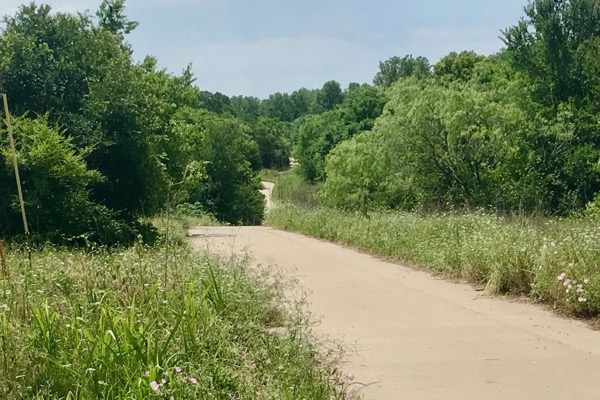 The concrete trail that runs from Gateway and Horse Trail Park. Photo by Amy Martin.
THE HIKE
Hiking companion: Scott Hudson
Season: Late spring
Distance: 7 miles
Time: 4.5 hours
The 12-foot wide concrete trail departs from the last parking lot at the Great Trinity Forest Gateway and Horse Trail Park. After a bend in the trail, the park disappears from view. Wide cleared areas flanking the path make it feel sun-blasted, the more refreshing forest so far away. Yet we hear the song of painted buntings emerging from treetops. A couple of bicyclists zip past us on the trail.
We walk past small illegal dumps of tires and tiles, and several clogged trail culverts and fetid pools from poor hydrological engineering. In a couple of places, the trail has steep inclines that only the most brave, muscle-bound wheelchair operator could scale.
Illegal dumping at McCommas Bluff Preserve. Photo by Amy Martin.
Dirt paths and old roads off to the right/east lead to degraded former sand and gravel mining areas. Not worth a gander, advises Scott. Young, scraggly trees emerging from piles of mining refuse barely screen the pits.
The trail takes a hard left/west to skirt the edge of the large Lincoln Memorial Cemetery. Scott points out creepy stacks of concrete slabs, the makings of burial vaults, oozing through the border fence. From this east-west section, dirt trails meander south through deep wet woods along the river.
MCCOMMAS BLUFF: HISTORY ASSAULTED
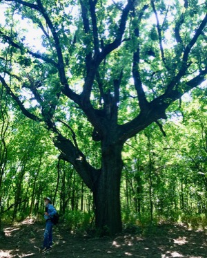 Scott Hudson walks past one of the large burr oaks in the forest. Photo by Amy Martin.
Scott and I turn right/north again through a lovely stretch of shady woods, the Trinity River a presence on our left, the cemetery to our right.
Abruptly, the trail disgorges onto the end of Riverwood Road. After the lush forest, it is shockingly barren and forlorn. Not a place to leave your car unattended, come alone or linger after dark.
This is the actual McCommas Bluff and the Riverwood Overlook as marked on Google Maps. It’s a rare rocky place in Dallas where you can walk right up to the edge of the Trinity River. A chalk expanse 100 to 130 feet wide that looks much like a parking lot spreads to the river. A couple of cars are parked. A Hispanic family packs up their gear. The river current is too strong for fishing.
What did this look like before? Old aerials show that hardwoods and meadows still flourished on the high river bluff. One could stand there and peer across the coursing river to lush wet woods abundant with birds. It’s the kind of beautiful spot that drew visitors to linger long before whites settled here.
Utility corridors from large to small traverse the Great Trinity Forest and a Dallas Water Utilities line was put through here. Such corridors are necessary part of urban living. But did it have to be done so wantonly? It seems more like an act of municipal vandalization, destruction for destruction’s sake.
It’s not just nature that was destroyed, but also history. When developers since the mid-1800s dreamed of Dallas as an inland port, the bluff was a focal point of upper Trinity River navigation. A Texas Historical Marker erected in 1986 is gone.
Beneath the rock, the soil is still rich. Imagine if some large native trees, grasses and wildflowers were installed. Parking spaces defined, rather than a rocky expanse perfect for spinning donuts in cars. A picnic table or two. Simple touches that make the statement: People care about this place. Instead, there is a wasteland of rock in one of the most historic and beautiful natural spots in Dallas.
TRINITY RIVER, RUNNING STRONG
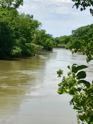 The Trinity River close to I-20. Photo by Amy Martin.
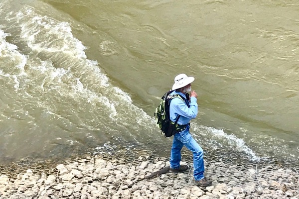
We walk to the bluff. Vertical steps of rock-filled wire gabions shore up the sides. The river flow is thick and fierce, far fuller than recent mild rains would cause. I’m puzzled. It’s a water release from upstream lakes, Scott informs, showing why you should always hike with someone smarter than yourself.
Remarkable to think that activities close to the Red River impact southeast Dallas. Water releases from Lake Ray Roberts northeast of Denton make their way to Lake Lewisville and on down the Elm Fork into the main stem of the Trinity. Life is so interconnected.
Looking over the abrupt ten-yard drop to the Trinity, there is slight turbulence from how the gabions pinch the river. Scott points out the remains of a lock downstream, more evidence of navigational dreams. Somewhere nearby, a lockkeeper’s house still stands.
 Scott Hudson climbs down to the river. Photo by Amy Martin.
Scott scampers down the gabions to a narrow slice of river shore. He must be part mountain goat. A man in a Dallas Parks and Recreation uniform leans over the bluff to look at Scott with a mix of astonishment and amusement.
THE WILD FOREST
“Brett, is that you?” I ask.
 A bois d'arc tree in the woods. Photo by Amy Martin.
Brett Johnson, urban biologist for the City of Dallas, temporarily pressed into park ranger duty, stands with Blake Wyne, parks supervisor for southeast Dallas. They’re here to check on a recently cleared encampment. A bunch of people at a 24/7 camp party can make one heck of a mess. Prior to cleanup, profuse trash littered the forest and improvised latrines leaked waste into the Trinity.
The encampment has been a consistent problem. Rumors swirl about activities like prostitution and drugs. It’s not uncommon to find bullet or shotgun casings on the trail. No wonder it’s persistent. It has a place marker on Google maps — McBluff Creek Camp — that identifies it as a campground. City efforts are underway to get the marker removed.
Heading northwest from the gravel expanse is an open corridor for underground utilities. Embattled bollards still stand at its entrance despite assaults by sledgehammers and saws to remove them. Huge concrete barriers once blocked the way, but someone brought in heavy equipment to illegally move some. Chainsaw vandals cut down adjacent trees. All so vehicles could rampage through the forest. A video camera now monitors.
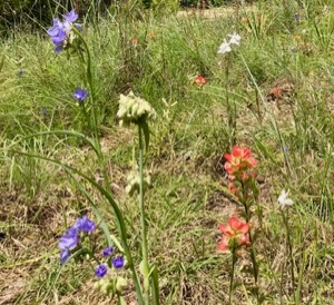
A MINI MEADOW CHARMS
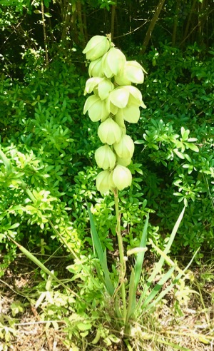 Native prairie yucca holds it own despite invasive privet. Photo by Amy Martin.
The park duo heads down the trail. Scott says, “You have to see this prairie,” and leads another way. Puzzling. All I see is forest and river. Then we turn between trees into a lovely intimate prairie, about the size of a mobile home.
It’s ultra-charming and makes me smile, the kind of sparse yet artfully arranged prairie that arises from shallow soils over limestone. Amid a pale teal wash of little bluestem grass (Schizachyrium scoparium), bright blue spiderwort (Tradescantia ohiensis) trails over the tops.
 A tiny prairie remnant in bloom. Photo by Amy Martin.
The bold neon orange of Texas paintbrush (Castilleja indivisa) and delicate white prairie larkspur (Delphinium carolinianum) and feisty woolly white (Hymenopappus scabiosaeus) punctuate the prairie. A native yucca (Yucca arkansana) holds court with its spiky leaves and towering flower stalk.
WOODS UNDER SIEGE
Scott and I continue down the utility corridor. Private land lies behind a fence to our right/northeast. A gorgeous spring-fed pond over there is so tempting and its bracingly cool overflow trickles across the trail. Further down, next to a private landowner gate that inexplicably opens to the corridor, gouged earth and other damage indicates the landowner appears to have helped himself to dirt and other resources from park property.
The trail is so close to the river, we must meander over for a look. We can gaze past where Elam Creek meets the Trinity and see gabions on the curve close to where the Trinity Forest Trail bridge crosses. The quiet is astounding; the trees are immense.
We return to the main trail and continue east a short distance to where the trail forks from the utility corridor into dense woods. A thought makes me shudder. Plans are to pave this path and the city insists on clearing a 50-foot swath for a 12-foot concrete trail. If that plan persists, all we’ve just seen will be demolished. It’s hard not to cry.
ELAM CREEK’S DEEP PEACE
We turn right/north on a narrow path that skirts a series of small meadows. The trail dips into a beautiful valley formed from Elam Creek. Soon we reach the end of Fairport Road, greeted by an illegal dump on the pavement. Another access point where I’d hesitate to come alone or leave my car.
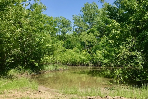
 A pond off the trail to Elam Creek. Photo by Amy Martin.
I turn to look back at the valley and it’s magical. Sunlight filters through branches and dances upon the leaves. Birds swoop through the glen in search of bugs to feed their young. Scott notices an Indigo Bunting male checking us out, moving from one treetop to another, encircling us with his song. I could stay here all day.
We return to the main trail and on to Elam Creek where concrete structures protect a pipe crossing. I’ve seen this spot so many times, but from the other side of the creek where a dirt trail extends from the Trinity Forest Trail, and vowed to reach it someday. And thanks to Scott, here I am!
Scott points out the rocks slightly downstream where crossing is possible if you’re willing to get a little wet in some seasons. Makes for quick access to the preserve from the Trinity Forest Trail parking lot located on the road to the Trinity River Audubon Center.
Elam Creek is a beautiful spring-fed waterway that begs further exploration past Fairport, but it’s time to be heading back. We are sad to leave this timeless place.
BOTTOMLAND BEAUTY
Retracing our path past McCommas Bluff, we rejoin the paved trail and hike to south of the cemetery. “Here we can continue or take the dirt trails through the woods,” says Scott.
The idea, of course, is irresistible. These woods are vast and deep.
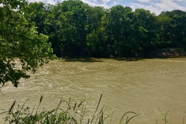 Turbulent waters of the Trinity River. Photo by Amy Martin.
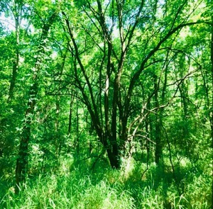
We dive into a forest with huge burr oaks, towering ash and enormous bois d’arcs amid a mess of young brushy trees — the sign of old pasture turned back to woods. Carpets of Virginia wild rye nod in a faint breeze. Cuckoos call, woodpeckers tap and songbirds sing in an arboreal symphony. The leaf litter crackles faintly with the movement of reptiles and the understory murmurs with woodland mammals going about their business.
The Trinity to our right/west underwent channelization, forcing the river’s natural sinews into a straight course. Channelization causes river water to flow with more velocity and only moves the flooding downstream. It denies the bottomland the periodic recharges that a spreading waterway provides. Now these woods receive river water only from epic floods when the Trinity overbanks. But somehow they hold on to their fecundity.
BOGGY DEVASTATION
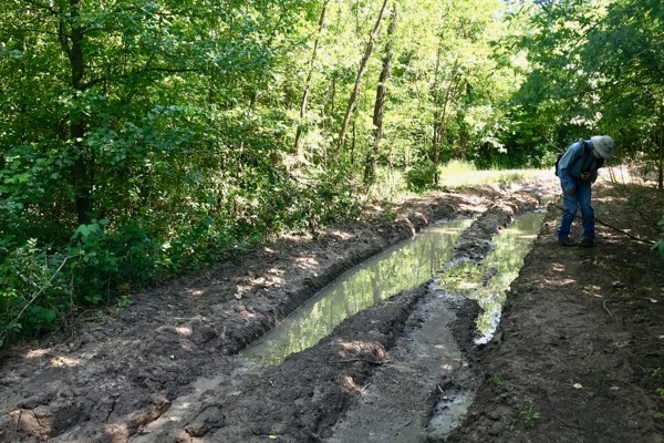 The area of forest close to I-20 is devastated by illegal ATV use. Photo by Amy Martin.
The trail becomes taken over by illegal ATV use. Miscreants who live for destruction race vehicles through here after rains, digging massive ruts in the soft bottomland soil. Once a path is gouged too deep for ATVs, drivers forge an adjacent one, sometimes by cutting down trees. The devastation spreads at times four lanes wide. The maze of deep ruts fills with water and breeds mosquitos.
Rampant destruction. A year ago it did not look like this. Now due to lax law enforcement and scant barriers, it is an ATV racetrack for a few and not a park for all. The annihilation of nature is heartbreaking. How could law enforcement allow this to continue unabated? Why is vandalizing, municipal and otherwise, so tolerated in the Great Trinity Forest?
The hike becomes a form of parkour, as we dip and dodge our way along narrow ridges left in the ATV morass, holding on to branches as we slide along muddy slopes. We take occasional side jaunts to look at the river. Across the Trinity exist a gorgeous forest and the river’s original meanders.
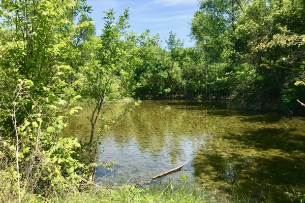
 A spring-fed pond close to the bluffs. Photo by Amy Martin.
FINDING HOME
Back on the trail, I revel in the wildness, even if smashed by ATV vandals, though the prevalence of wild hog tracks is disturbing. Scott looks back at me and exclaims, “You look so happy!” I reply, “I am! I get to follow you and don’t have to worry about getting lost. I can just take it all in.”
We continue south, both of us gawking at the intense beauty of the trees and searching for birds. Then we notice that I-20 is visible. The roar of traffic is intense. Ooops! Somewhere in that ATV morass was the trail back to the parking lot. But we’re not lost; just temporarily misplaced.
We retrace our steps and find a different route, even wetter and more ruined than what we were on. There is no choice but to wade on though, splashing like a couple of kids on an adventure, which we are. For sure, it’s an afternoon for the memory banks.
RELATED ARTICLES
Great Trinity Forest Trail Series:
PART 1 : Paved Trinity Forest Trail connects natural landmarks
PART 2: Trinity Forest Trail turns into shady retreat on second foray
PART 3: Peaceful landscape awaits on last leg of Trinity Forest Trail
White Rock Creek Trail offers respite during lockdown
Stay up to date on everything green in North Texas, including the latest news and events! Sign up for the weekly Green Source DFW Newsletter! Follow us on Facebook and Twitter. Also check out our new podcast The Texas Green Report, available on your favorite podcast app.
Author

AMY MARTIN
Amy Martin, a journalist and writer for more than 40 years, is a senior reporter for GreenSource DFW. Her latest book, "Wild DFW: Explore the Amazing Nature in and round Dallas-Fort Worth,” (Wild-DFW.com) will be released by Timber Press in July 2023. She is currently creating a biographical website (NedFritz.com) of Ned Fritz, Texas' most famous environmentalist. Her prior book was "Itchy Business: How to Treat the Poison Ivy and Poison Oak Rash, Prevent Exposure and Eradicate the Plant.”(Itchy.biz) She was contributing editor for the national magazine Garbage (recycling and features), and has written for TheaterJones (comedy and cirque), Senior Voice (The Aging Hippie column), Dallas Morning News (recycling), Dallas Times Herald (performing arts), and Dallas Observer (music and comedy). For a dozen years, Martin also operated a popular alternative news service called Moonlady News, earning her the nickname Moonlady. She may be reached through Moonlady.com.